Biodiversity blind spots: Why the next frontier of sustainability needs GeoAI
For years, biodiversity sat just outside the core of most corporate sustainability strategies. It was acknowledged but rarely measured, recognized...
Please note that this article was originally written in April 2023. Since then a lot has changed with the EUDR. See here for the latest about how Picterra can help you become compliant.
—
According to the Food and Agriculture Organization of the United Nations (FAO), approximately 178 million hectares of forest—an area roughly the size of Libya—have been lost worldwide between 1990 and 2020, emphasizing the pressing need for decisive action against deforestation.
The European Parliament recently adopted the EU Deforestation Regulation (EUDR), a groundbreaking law to fight global deforestation, aiming to ensure that products imported into the European Union are not associated with deforestation or forest degradation. This new legislation, also known as regulation (eu) 2023/1115, is a significant step forward, but its implementation and enforcement will require advanced technology to monitor and analyze land-use changes across the globe.
Enter geospatial AI, a cutting-edge technology capable of processing vast amounts of satellite and drone imagery to identify patterns, trends, and risks. This blog post delves into the potential of geospatial AI to bolster the EU’s efforts to fight global deforestation and highlights the crucial role played by companies like Picterra in ensuring EUDR compliance.
The EU Deforestation Regulation (EUDR) is a landmark piece of legislation that aims to halt the import of commodities associated with deforestation into the European Union. The regulation affects a broad range of commodities that have been linked to deforestation and forest degradation around the world. Here are some of the key commodities that fall under the purview of the EUDR:
Geospatial AI can detect changes in land use and forest cover quickly and accurately by analyzing satellite and drone imagery. This allows for real-time monitoring of potential deforestation or degradation activities in remote locations, ensuring that authorities can quickly identify and address violations of the EU Deforestation Regulation.
Geospatial AI technology can be used to assess deforestation risks by comparing historical and current imagery data. By identifying areas with significant deforestation or forest degradation, authorities can prioritize inspections and enforce the EUDR more effectively.
Geospatial AI can help companies meet the requirements of the new EU deforestation law by monitoring their deforestation-free supply chains. Analyzing satellite and drone imagery enables businesses to ensure that their suppliers are not engaged in deforestation or forest degradation activities and comply with the law’s deforestation due diligence requirements.
Beyond enforcement, Picterra’s AI can also support reforestation and conservation efforts by identifying degraded areas that require restoration or protection. This can help governments and organizations allocate resources efficiently and develop targeted, evidence-based strategies for forest conservation.
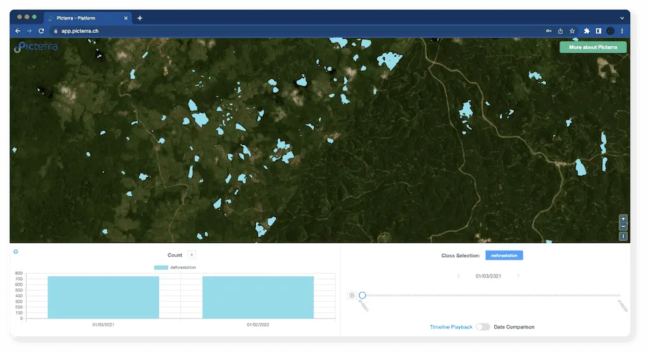
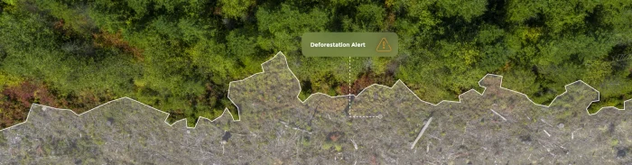
Global Forest Watch (GFW), a platform that provides near-real-time forest change data, leverages geospatial AI to monitor deforestation worldwide. GFW combines satellite imagery and advanced algorithms to identify areas with significant forest cover loss and provide alerts to governments, NGOs, and other stakeholders.
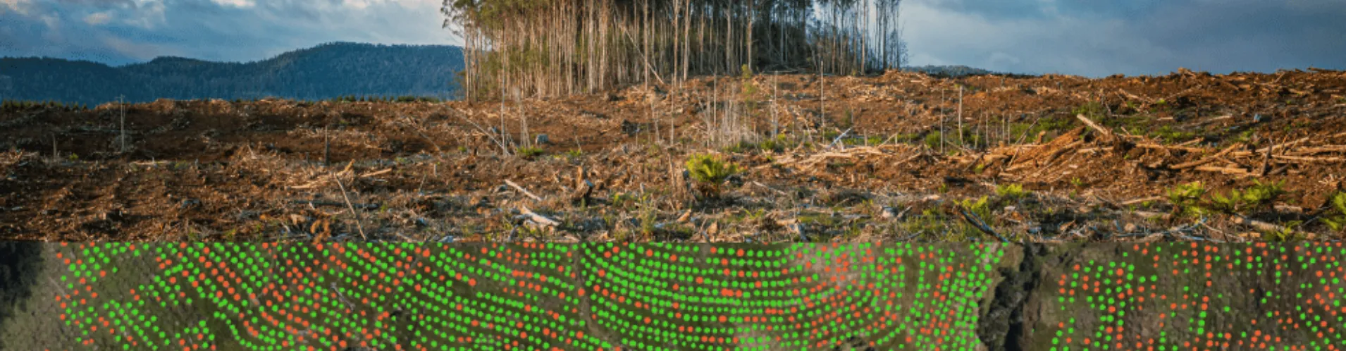
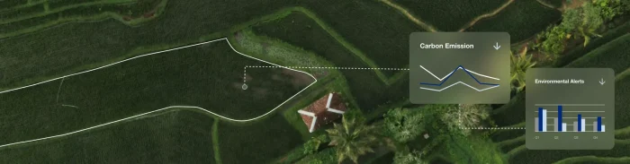
SkyFi, a provider of advanced aerial data and analytics solutions, collaborated with Picterra to track the environmental footprint of mining activities using geospatial AI technology. By combining SkyFi’s high-resolution aerial imagery with Picterra’s machine learning algorithms, they were able to monitor land-use changes, detect early signs of deforestation, and assess the impact of mining operations on surrounding ecosystems. Click here to read more.
The Rainforest Foundation, an organization committed to preserving rainforests and supporting indigenous communities, has partnered with Planet, an earth observation company, to utilize geospatial AI technology. The collaboration aims to monitor illegal logging activities and provide evidence to local authorities to enforce legal actions against violators.
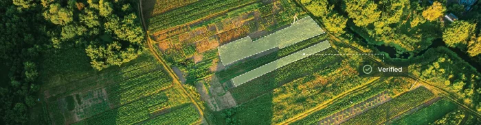
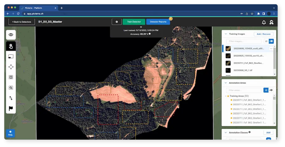
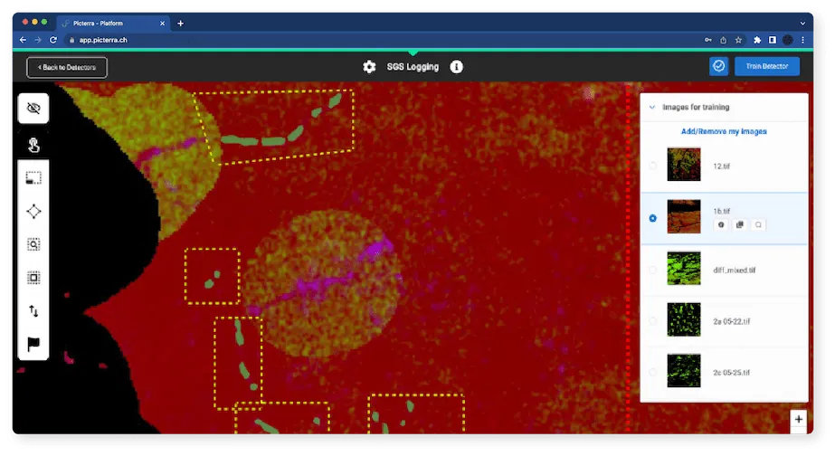
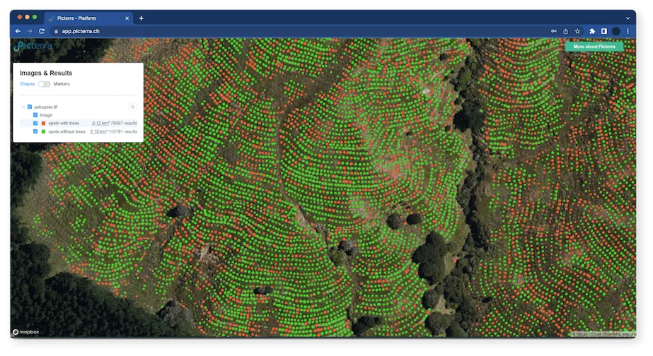
SGS, a leading inspection, verification, testing, and certification company, partnered with Picterra to leverage its geospatial AI technology in monitoring and protecting the world’s forests. By utilizing machine learning and satellite imagery analysis, SGS was able to detect and track deforestation events, assess compliance with forestry regulations, and efficiently report the findings to relevant stakeholders. Click here to read more.
In Indonesia, the government has partnered with organizations such as Global Forest Watch and the World Resources Institute to harness geospatial AI technology in monitoring and enforcing the country’s moratorium on new logging permits. The collaboration has helped the Indonesian government identify and prosecute companies that have breached the moratorium, reducing deforestation rates significantly.
As a leading geospatial AI company, Picterra is well-positioned to contribute to the EU’s efforts in fighting global deforestation. By offering state-of-the-art AI and satellite imaging capabilities, Picterra enables governments, NGOs, and businesses to harness the power of geospatial AI for monitoring land-use changes, assessing deforestation risks, and ensuring EUDR compliance.
Furthermore, Picterra’s technology can support reforestation and conservation efforts by identifying degraded areas that require restoration or protection. This can help governments and organizations allocate resources efficiently and develop targeted, evidence-based strategies for forest conservation.
As global deforestation continues to pose a significant threat to biodiversity, climate, and human well-being, the new EU Deforestation Regulation marks a crucial step in addressing this challenge. The power of geospatial AI, as demonstrated through various use cases and success stories, offers the potential to revolutionize the monitoring, enforcement, and mitigation of deforestation worldwide.
With companies like Picterra leading the way in geospatial AI technology, the European Union and its member states can more effectively enforce the new legislation and drive sustainable change. By embracing the potential of geospatial AI, the EU is better equipped to achieve its ambitious goal of halting global deforestation and securing a more sustainable future for all.
For years, biodiversity sat just outside the core of most corporate sustainability strategies. It was acknowledged but rarely measured, recognized...
Carbon markets were created to make climate action more scalable. By assigning financial value to emissions reductions and carbon storage,...
Sustainability compliance used to revolve around documentation. Was a certificate available? Could a supplier confirm something in writing? Was an...
Regenerative agriculture is no longer just a fringe idea. Once regarded as a niche approach championed by a handful of...