Eramet, a global leader in the mining and metallurgy industry, has been at the forefront of sustainable mineral development and innovation. With a diverse portfolio ranging from manganese and nickel to lithium, Eramet is dedicated to enhancing the efficiency and sustainability of its operations. The company continuously seeks advanced technological solutions to optimize its geospatial data management and analysis as part of this commitment.
Picterra, a pioneering platform in GeoAI analysis, offers cutting-edge AI-powered solutions for various industries, including mining. Its platform empowers professionals to leverage geospatial data without extensive data science expertise, making it ideal for companies like Eramet.
This case study illustrates the transformative impact of Picterra’s platform on Eramet’s operations.

GIS Product Manager, Eramet
One of the key challenges Eramet faced in managing and analyzing geospatial data across its global operations was identifying a solution that could make GeoAI analysis tools accessible and user-friendly for a broader range of users. Eramet’s teams, spread across various regions and disciplines, needed to utilize geospatial data without relying on a centralized, dedicated data science team. This decentralization ensured that geospatial insights could be swiftly integrated into daily operations, from exploration and site rehabilitation to environmental monitoring and geotechnical assessments.
During the pilot phase, Eramet worked closely with Picterra to identify and develop relevant use cases. This phase was crucial for understanding the platform’s capabilities and how it could be integrated into Eramet’s existing workflows. The collaboration involved extensive testing and refinement, ensuring that the solutions provided by Picterra could meet the specific needs of different teams within Eramet.
A key aspect of Picterra’s implementation was its interoperability with other Eramet platforms. Picterra’s ability to seamlessly integrate with Eramet’s existing GIS systems, such as ESRI ArcGIS, was vital. This integration allowed for a smooth transition and ensured that geospatial data could be efficiently managed and analyzed within Eramet’s established technological ecosystem.
Picterra’s API capabilities were particularly beneficial, enabling Eramet to integrate Picterra’s tools into their custom workflows and data pipelines. The interoperability extended to various data sources, including public satellite data and Eramet’s high-resolution imagery, making incorporating diverse datasets into their analyses easier.
Throughout the implementation process, Eramet gained valuable insights into how best to leverage Picterra’s platform. One key learning was the importance of tailored training and support. Picterra provided comprehensive training sessions that equipped Eramet’s staff with the necessary skills to utilize the platform effectively. This training focused on understanding AI concepts, handling geospatial data, and optimizing model accuracy.
Another significant learning was Picterra’s platform’s adaptability to different user profiles within Eramet. The platform’s intuitive interface allowed users with varying technical expertise to engage with geospatial data and develop custom detectors without extensive coding knowledge. This adaptability ensured widespread adoption across Eramet’s teams, from GIS specialists to mining engineers.
After a successful pilot phase, Eramet began scaling up the use of Picterra’s platform. This transition involved expanding the use cases and integrating Picterra into regular and critical operations. Eramet established criteria for scaling up, which included evaluating the platform’s impact on project turnaround times, data accuracy, and overall operational efficiency—the positive feedback from initial users and the demonstrated benefits led to broader adoption across the organization.

GIS Engineer – Exploration department, Eramet
Picterra’s platform has proven to be a valuable asset across various operational areas, from the initial pilot projects to the scaled-up services.
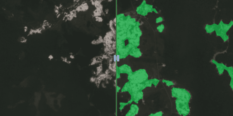
Picterra has been instrumental in automating and accelerating the evaluation of potential mining sites. By quickly analyzing large and remote areas, Picterra has helped Eramet identify viable targets more efficiently, supporting its exploration strategies.
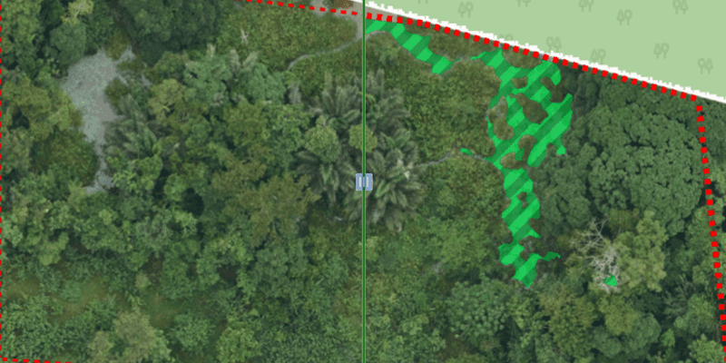
Detailed geotechnical assessments are necessary to ensure the stability and safety of mining operations. Picterra has enabled Eramet to integrate geospatial data with other geological information, providing a comprehensive view of site conditions. This integration has facilitated proactive risk management and improved the safety of mining activities.
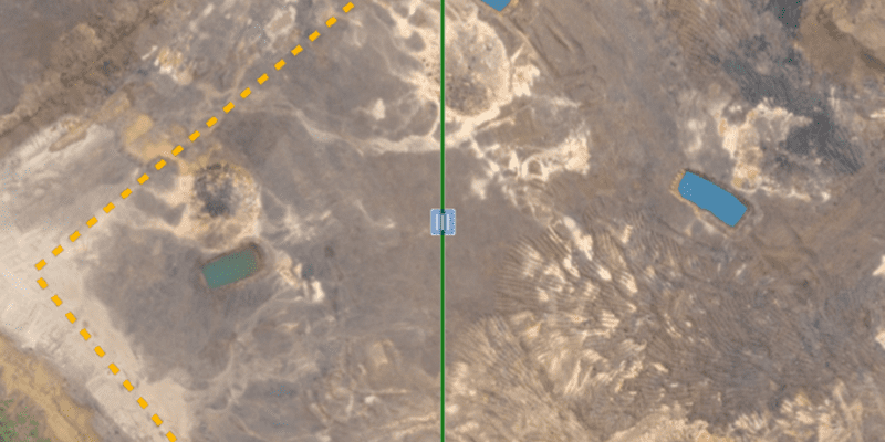
Proper water management is essential to avoid operational disruptions and environmental impacts. Picterra’s platform has allowed Eramet to detect and monitor water bodies around their mining sites accurately. This capability has supported better water resource management and planning.
GIS Product Manager, Eramet
The partnership between Eramet and Picterra has demonstrated the transformative power of advanced GeoAI analysis in the mining industry. By addressing Eramet’s challenges in geospatial data management, Picterra has enabled the company to achieve greater efficiency, accuracy, and autonomy in its operations. The successful implementation and scaling of Picterra’s platform have underscored its value as a strategic tool for Eramet’s diverse use cases, from exploration and rehabilitation to geotechnical analysis and water management.
Picterra’s accessible tools have enabled more users to engage directly with geospatial data, reducing reliance on centralized resources.
Picterra provides a flexible platform to handle multiple geospatial needs with seamless integration and rapid deployment.
Picterra has improved turnaround times and data quality, enabling quicker decisions and more agile responses across operations.

