
Introducing The GeoAI Imperative for Commodity Sourcing
Reflections from our Climate Week Zurich session on what it actually takes to move geospatial intelligence from sustainability dashboards into...
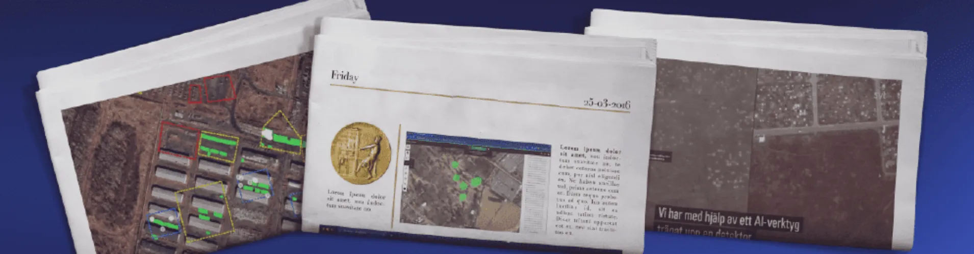
In an era where information is abundant but often elusive, the ability to uncover hidden truths has never been more critical. For investigative journalists and OSINT (Open Source Intelligence) professionals, the challenge lies in accessing and interpreting data to reveal what’s happening on the ground. This is where GeoAI—Geospatial Artificial Intelligence—comes into play. By merging the analytical power of AI with satellite, drone, and other top-down imagery, GeoAI offers a new perspective on events that are otherwise difficult to observe.
GeoAI is transforming the field of investigative journalism by enabling professionals to go beyond traditional sources and discover ground truth from above. Whether monitoring conflicts, exposing environmental damage, or tracking geopolitical movements, GeoAI allows journalists and analysts to uncover evidence that might otherwise remain hidden. This approach doesn’t just enhance storytelling; it provides a level of verification and context that traditional methods alone often cannot achieve.
At Picterra, we’ve had the opportunity to support journalists and media organizations in groundbreaking investigations, equipping them with the tools to analyze and interpret geospatial data with ease and precision. From assessing the impact of conflicts to tracking changes in sensitive areas, our platform empowers journalists to transform imagery into compelling evidence, helping them hold power to account and tell stories that matter.
In this blog, we’ll explore how GeoAI and space data are revolutionizing investigative journalism. We’ll provide practical guidance on sourcing imagery, building AI models, and ensuring reliable and ethical investigations. Let’s dive into the power of GeoAI and how it’s redefining how we uncover and report the truth.
GeoAI combines the power of geospatial data with AI-driven analytics to detect patterns, identify changes, and draw insights from imagery and spatial information. While AI has been widely used across various industries, GeoAI focuses on analyzing images captured from above—such as satellite, drone, and aerial photos—to understand the physical world better. This technology goes beyond just looking at images; it automates the recognition of objects, changes, and anomalies in ways that would be time-consuming and sometimes impossible for human analysts to achieve manually.
The increasing accessibility of satellite and drone imagery has opened new avenues for investigative journalism and OSINT. Journalists can now corroborate on-the-ground reports, reveal hidden activities, and verify events by comparing images over time. From tracking deforestation to monitoring conflict zones, GeoAI helps surface critical evidence by analyzing vast amounts of imagery that would otherwise remain underutilized.
OSINT, on the other hand, refers to gathering and analyzing information from publicly available sources. This approach has been a cornerstone of investigative journalism for decades, allowing reporters to piece together information from documents, social media, videos, and more. However, as the volume and complexity of available data have grown, OSINT has increasingly relied on advanced tools like GeoAI to extract meaningful information from imagery.
The convergence of GeoAI and OSINT is reshaping the landscape of investigative journalism. By integrating AI-driven analysis with open-source data, journalists can validate their findings, add visual evidence to their stories, and provide readers with transparency and accuracy that text alone cannot convey. GeoAI doesn’t just offer a new way to look at data; it provides a powerful tool to uncover hidden truths and present them with the rigor and clarity that modern audiences expect.

The impact of GeoAI on investigative journalism goes beyond mere data analysis—it’s about unveiling stories that were previously hidden or impossible to report. By leveraging the power of AI-driven image analysis, journalists can investigate events and activities on a global scale, providing visual evidence to support their work. Here are some of the key ways GeoAI is being applied in investigative journalism:
Conflict monitoring and damage assessment: In conflict zones, where access is restricted and information is often manipulated, GeoAI can provide an unbiased view from above. By analyzing satellite imagery, journalists can assess the extent of damage to infrastructure, identify troop movements, and verify reports of attacks on civilian areas. This allows for detailed, evidence-based reporting that enhances understanding of the ground situation.
Environmental investigations and climate impact analysis: From tracking illegal deforestation to monitoring pollution and the effects of climate change, GeoAI is invaluable for environmental journalism. It enables the identification of changes in land use, illegal mining activities, and other environmental violations by automating the detection of specific patterns in large datasets, empowering journalists to quantify environmental damage.
Tracking military movements and geopolitical analysis: GeoAI has become crucial in geopolitical reporting. Journalists use satellite imagery and AI models to track military equipment, monitor troop movements, and assess the impact of political or military actions. This visual context enhances traditional reporting methods, offering deeper insights into unfolding events.
Uncovering hidden or restricted sites and activities: Journalists can use GeoAI to investigate inaccessible or intentionally obscured sites. This includes identifying undisclosed facilities, analyzing land changes, and detecting patterns indicative of hidden activities. GeoAI provides the ability to visualize and validate information that would otherwise be speculative.
The success of GeoAI-driven investigations hinges on the quality and availability of imagery. Various open-source and commercial imagery sources are accessible to journalists, enabling them to acquire the data needed for their investigations. Below are key sources for obtaining satellite, drone, and aerial imagery:
Considerations for imagery use: Some commercial providers, including Airbus, have specific corporate policies that restrict the publication of images related to sensitive topics, such as the wars in Ukraine and Gaza. Since Picterra is an imagery-agnostic platform, it’s up to the journalists to verify their publishing rights and comply with any restrictions the data providers impose. Picterra maintains relationships with multiple imagery providers, including Airbus, Planet, Skywatch, ICEye, Umbra, Hexagon, and BlackSky, allowing users to integrate various data sources based on their specific needs and permissions.
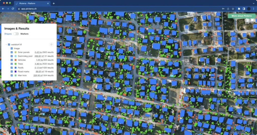
Creating effective GeoAI models is key to transforming raw imagery into evidence. Picterra’s platform simplifies this process, enabling journalists and OSINT professionals to build, train, and deploy custom AI models tailored to their specific investigative needs. Here’s how you can use Picterra to analyze imagery and uncover the stories hidden within:
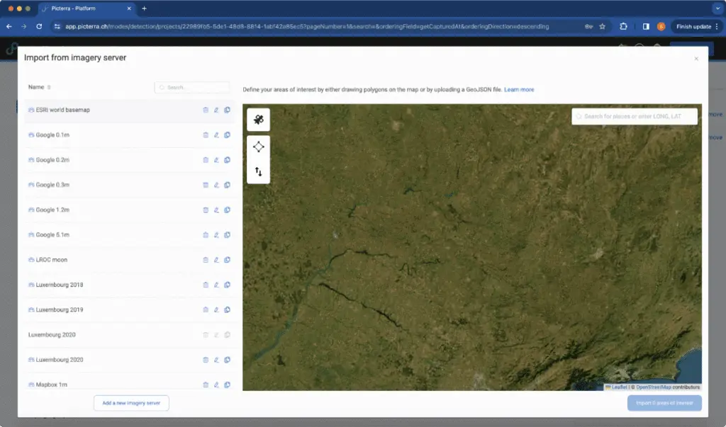
Step 1: Upload your imagery and define areas of interest
Begin by uploading your chosen satellite, drone, or aerial imagery to the Picterra platform. Picterra supports a wide range of imagery sources, making it easy to work with data from both open-source and commercial providers. Once uploaded, define the areas of interest within your images—whether you’re focusing on conflict zones, environmental changes, or other investigative targets.
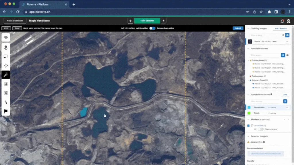
Step 2: Create and train a custom AI model
One of the most frequently asked questions when building a model is: What can the AI detect? The answer is straightforward—if you or a subject matter expert (SME) can see and identify it in the image, you can train a model to detect it. Picterra’s platform empowers users to annotate examples of visible features in the imagery, such as vehicles, buildings, craters, deforestation patterns, or specific types of equipment.
Picterra’s annotation tools make this process intuitive and efficient. The platform includes an AI Magic Wand feature that simplifies annotation by automatically detecting and outlining objects based on initial clicks. This tool speeds up the creation of training data, allowing you to mark multiple examples quickly with minimal effort and significantly reduce the manual workload. The Magic Wand helps ensure consistent annotations, making the training process smoother and more accurate.
Whether using high-resolution commercial imagery or open-source data, the key is that the object or pattern is visible and distinguishable. For instance, models can be trained on satellite images with a resolution of about 30 cm per pixel to detect larger objects like tanks or building damage. Higher-resolution images—such as those captured by drones or specialized satellites—are often more effective for smaller, detailed features.
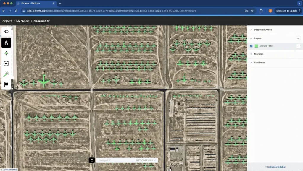
Step 3: Automate detection and analysis
After training, deploy your AI model to detect and analyze patterns across large datasets automatically. This step is crucial when working with vast amounts of imagery, allowing the AI to process data and highlight relevant findings quickly. For instance, you can use Picterra to automatically identify changes in infrastructure, track environmental degradation, or monitor movements in conflict zones.
Step 4: Validate and interpret the findings
Validation is critical to the investigative process, ensuring that the AI detections are accurate and reliable. While Picterra excels in detecting patterns, many journalists employ additional workflows to verify these findings. For example, The New York Times used a detailed workflow to investigate crater detections in Ukraine. After exporting detections from Picterra:
This validation workflow helps ensure that only relevant and new findings are included in the final analysis, enhancing the investigation’s credibility and impact.
Step 5: Export data and integrate it into your reporting
Once validated, Picterra allows you to export the detected data in various formats, making integrating findings into your reporting easy. Whether creating visuals for a publication, sharing data with colleagues, or presenting evidence to an audience, Picterra’s export options ensure that your insights are accessible and impactful.
Learn more about all of these steps by checking out Picterra’s documentation.
Using GeoAI effectively requires not just technical skills but also a thoughtful approach to ensure the results are accurate, ethical, and impactful. Here are some best practices and tips for journalists and OSINT professionals when integrating GeoAI into their investigations:
Before diving into the data, define the purpose of your investigation. What are you trying to uncover or prove? Clear objectives help guide the selection of imagery, the design of AI models, and the validation processes. Whether tracking military movements or assessing environmental damage, having a focused question will streamline the workflow and ensure you gather the most relevant data.
The quality of your findings directly depends on the imagery you use. Choose your imagery source based on the specifics of your investigation. For example, high-resolution commercial imagery is ideal for detailed analysis, such as identifying small objects or subtle changes. On the other hand, open-source platforms like Sentinel Hub or NASA’s EOSDIS are great for broad environmental monitoring and change detection over larger areas. Always ensure that the resolution matches the scale and complexity of what you need to detect.
Collaborating with SMEs can significantly enhance the quality of your AI model training. Experts can help identify critical features that may not be immediately obvious, ensuring that your annotations accurately represent the objects or patterns of interest. This collaboration is particularly useful in niche or technical fields where expertise can guide more nuanced model development.
Validation is essential to ensure the reliability of your GeoAI outputs. Use additional workflows, like side-by-side image comparisons or manual checks, to confirm the AI’s detections. Filtering out false positives and verifying detections with other data sources strengthens the credibility of your findings and helps avoid publishing inaccuracies. Always be prepared to cross-reference your GeoAI results with independent sources, such as ground reports, additional satellite imagery, or other open-source data.
Ethical considerations are paramount when working with sensitive data, particularly in conflict zones or areas under surveillance. Be mindful of privacy implications, data sensitivity, and the potential impact of your findings on affected communities. GeoAI’s power to reveal hidden truths also comes with responsibility; always ensure that your work respects legal and ethical boundaries, including the rights of individuals who may be inadvertently captured in imagery.
Present your GeoAI findings in a way that’s accessible and understandable for your audience. Use clear visuals, such as annotated maps, before-and-after comparisons, or interactive elements to help readers grasp the significance of your work. Explain your methodology transparently, including how data was sourced, what AI models were used, and any analysis limitations whenever possible. Transparency builds trust and helps readers appreciate the depth and rigor of your investigation.
Picterra’s platform is designed to be user-friendly, but complex investigations can benefit from additional guidance. Utilize Picterra’s support resources, community forums, and expert consultations to troubleshoot challenges, refine your models, and stay updated on best practices. Engaging with the wider GeoAI community can provide valuable insights and new approaches to your investigative work.
GeoAI has become an essential tool for journalists covering complex and sensitive topics, particularly in conflict zones. By combining aerial imagery with AI-driven analysis, investigative teams can uncover crucial evidence that would remain hidden, adding depth and context to their reporting. Below are some significant investigations where GeoAI played a critical role:
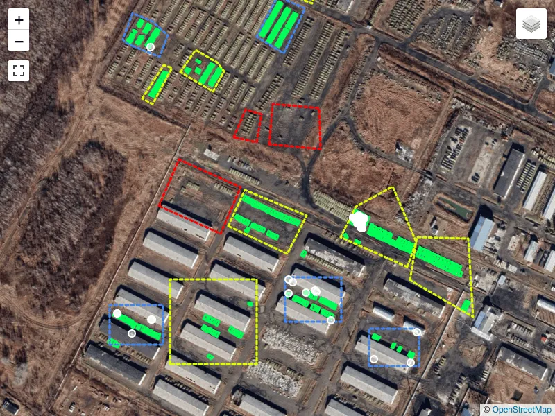
The New York Times used GeoAI to analyze bomb craters left by 2,000-pound bombs in south Gaza, where Israel had directed civilians to take shelter. The investigation revealed that these powerful bombs were used routinely in areas designated as safe zones, raising serious questions about the impact on civilian safety. The project relied heavily on aerial imagery and AI to detect and map craters, providing visual evidence that supported the team’s broader investigation.
The investigative team used Picterra to build a custom AI model specifically designed to detect bomb craters in satellite imagery. The process began with training data: the team manually annotated examples of craters across different images to teach the AI what to look for. The model was trained on a diverse imagery set from various dates and locations to detect craters of different sizes and shapes accurately. This process involved a back-and-forth between initial model outputs and refinement, with the AI improving its accuracy as more annotated examples were added.
Once the model was trained, it was deployed to scan large areas of satellite imagery, identifying craters across multiple scenes. According to Ishaan Jhaveri, the process allowed the team to detect over a thousand potential craters in minutes, which would have been prohibitively time-consuming to do manually. This automated detection was crucial given the scale of the area and the volume of imagery analyzed.
To ensure accuracy, the team then engaged in a detailed validation process. They used QGIS to draw boxes around each detected crater, merging those within 100 meters of each other, and compared recent satellite images with those from earlier in the conflict to verify that the craters were newly formed. This step filtered out false positives and clarified where and when the bombs had impacted.
Jhaveri emphasized the importance of using AI to handle such complex tasks: “We didn’t use AI to replace what would’ve otherwise been done manually. We used AI precisely because it was the type of task that would’ve taken so long to do manually that [it would distract from] other investigative work. AI can help investigative reporters find the needle in the haystack.” The efficiency and precision of GeoAI allowed the team to focus on deeper investigative elements while maintaining a high level of accuracy.
The investigation was recognized with a Pulitzer Prize for its innovative use of AI in journalism, highlighting the value of technology in revealing hidden truths within complex conflict scenarios.

Süddeutsche Zeitung’s investigation focused on Russia’s dwindling tank reserves, revealing how Vladimir Putin’s forces were increasingly stretched thin. Using GeoAI, the team analyzed satellite images of Russian military bases to monitor the number of tanks and armored vehicles over time. This analysis provided a clear visual narrative of Russia’s diminishing military resources, offering rare insights into the logistical challenges faced by the Kremlin as the war in Ukraine continued.
GeoAI was used to detect and track changes in the bases, with Picterra facilitating the automated identification of tanks within large, complex imagery datasets. This work provided a detailed look at how sanctions and battlefield losses affected Russia’s military capacity, bringing a level of evidence-based reporting that traditional methods alone could not achieve.
In their recent visual investigation, the Süddeutsche Zeitung team utilized an AI-driven tool to analyze satellite images over time, providing a simple yet highly effective method to quantify changes on the ground. “This technological breakthrough allowed us to conduct an unprecedented level of OSINT analysis on Russian tank movements, shedding light on crucial developments in the ongoing and unjust war against Ukraine”, says Ben Heubl, investigative journalist at Süddeutsche Zeitung.”Without the capabilities provided by AI, such a sophisticated analysis would have been impossible, underscoring the transformative potential of artificial intelligence in investigative journalism and its role in uncovering the truth amidst global conflicts”.

Swedish broadcaster SVT used GeoAI to investigate the rapid expansion of cemeteries in Ukraine, aiming to quantify the human cost of the war. SVT leveraged Picterra’s change detection functionality, which allows users to compare images over time to identify changes in specific areas. This tool enabled the investigative team to track how quickly cemeteries were expanding during the conflict compared to pre-war conditions, offering a stark visual representation of the increasing number of casualties.
Picterra’s change detection feature simplifies temporal data analysis, automatically highlighting areas of change and allowing users to pinpoint exactly where expansions occurred. This capability was crucial for SVT, as it provided a clear and data-driven visual narrative of how the war was impacting communities on the ground.
GeoAI is revolutionizing investigative journalism and OSINT, empowering journalists to uncover hidden truths and present compelling evidence through visual data. From conflict zones to environmental crises, GeoAI allows for a deeper and more precise analysis of the world, providing insights that traditional methods often miss. The recent investigations by The New York Times, Süddeutsche Zeitung, and SVT are prime examples of how combining AI with geospatial imagery can clarify complex and sensitive issues, offering audiences a clearer understanding of unfolding events.
As the technology evolves, the applications of GeoAI in journalism will continue to expand. The ability to train custom AI models tailored to specific investigative needs, coupled with the growing accessibility of both open-source and commercial satellite imagery, means that more journalists will have the tools to conduct in-depth, evidence-based reporting. Platforms like Picterra are at the forefront of this shift, making GeoAI accessible and user-friendly, even for those without technical expertise.
However, the use of GeoAI also brings responsibilities. Ensuring AI models’ accuracy, rigorously validating findings, and respecting ethical considerations are crucial steps that must not be overlooked. Journalists must continue to balance the power of technology with careful, critical analysis and maintain transparency about their methods to build trust with their audiences.
The future of GeoAI in journalism is not just about uncovering what’s hidden but about enhancing the way we understand the world around us. By embracing this technology thoughtfully, journalists can provide new perspectives, reveal critical evidence, and hold those in power accountable. As we look ahead, the integration of AI in journalism will shape the stories we tell and how we tell them—ensuring that the search for truth remains at the heart of investigative work.
Connect with Picterra
For journalists and OSINT teams looking to integrate GeoAI into their work, Picterra offers access to powerful tools and support for sourcing imagery, building models, and validating findings. Contact us to learn more about how our platform can help you uncover the stories that matter. Whether you need assistance accessing the right imagery or creating custom AI models, our team supports your investigative efforts at every step.
Reflections from our Climate Week Zurich session on what it actually takes to move geospatial intelligence from sustainability dashboards into...

Reflections from our Climate Week Zurich session on what it actually takes to move geospatial intelligence from sustainability dashboards into...
Brazil is heading toward a record coffee harvest. At least, that’s the headline.Brazil’s national supply agency, CONAB, is projecting 66.2...

Lausanne, Switzerland – May 14, 2025 – Picterra, a leading platform for geospatial artificial intelligence (GeoAI), today announced the availability of its solution...